Friday, 18 November 2016

Setting Boundaries

Setting Boundaries

The last strategy involves identifying and setting clear boundaries for important thresholds in socio-ecological systems (SES). Many SESs can exist in several “self organising states” (Biggs, et al., 2015) that shift from one to another when critical thresholds are passed that collapse the structure behind the system. Such drastic shifts could have substantial impacts for both society and the environment. Robustness plays a role here. How robust a SES is ultimately affects the degree which its structure can endure shocks to its systems (Carlson & Doyle, 2002).  

The difficulty lies in identifying the critical point where a regime shift occurs. Biggs, et al (2015) describe the underlying variables behind such drastic shifts as “almost always unknown, varying between systems and change over time”. Thus creating the problem of ontological complexity which adds uncertainty to one’s understanding of when regime shifts might occur.
Yet, we can estimate such critical thresholds by extrapolating them from observations of similar regime shifts in similar SES. To even further reduce this uncertainty, it is also possible to add an additional boundary from the threshold point to reduce the likelihood of hitting that boundary. The length on the additional boundary from the threshold point can be varied depending on the unique factors tied to the SES and adjusted accordingly if circumstances change.
I couldn’t find specific examples of boundaries used in the governance of SES in Singapore but I would imagine they are there based on what I have read thus far. For example, I came across this presentation[1] made by the Public Utilities Board (PUB) that made mention of a 42 month study to establish a baseline for ecosystem biodiversity in all reservoirs. The study took random samples across both disturbed and undisturbed zones of reservoirs by using traps and nets to capture species in the area. By doing so, the researchers hoped to identify the current biodiversity levels in the reservoirs and seek to maintain them.
I thought this was a really good indication of a threshold as it showed that the authorities were looking into the normal levels of biodiversity in the reservoir. By constantly monitoring this marker, authorities can act when the biodiversity levels fall below the norm to prevent drastic regime shifts.
Another interesting aspect of the study was that of alien species; those non-native to the reservoirs. It found that Bedok Reservoir had a significant “alien” presence which whilst strengthening its biodiversity also could cause a shift in the structure holding the reservoir together. Thus, I feel that a single marker isn’t enough in the employment of boundaries. Instead, a variety of markers need to be used to ensure sufficient coverage of the issues facing the SES.
Another place where boundaries could be heavily used is that of water quality in the reservoirs. With 2/3 of Singapore being water catchment areas, it is imperative that the water quality of these areas be monitored to ensure they are safe for human consumption. The PUB constantly monitors the water quality of the reservoirs according to legislation and these standards are released to the public (Public Utilities Board, 2016). There is a range given in the water quality which seems to be the boundary we discussed earlier. Thus there clearly are boundaries set in place to ensure the quality of the water.


[1] https://www.cbd.int/doc/meetings/nbsap/nbsapcbw-seasi-01/other/nbsapcbw-seasi-01-sg-water-en.pdf

Facilitate Self Organisation

14b

Facilitate Self Organisation

SES are self-organising systems that constantly adjust and reorganise in response to changes; both external and internal (Biggs, et al., 2015). Self-organisation implies a structure in a system without a central authority or external forces deciding (Biggs, et al., 2015). The mechanism that allows for this are the feedback loops between parts of the system that reinforce or dampen system effects. Over time, some of these feedbacks become dominant and lead to a structure in the SES. Resilience also matters here because shocks which are large enough can cause a structure to change drastically (Biggs, et al., 2015).
The key according to Biggs, et al (2015) is to understand the nature of these feedback loops and “working with” systems to develop self-organisation by identifying leverage points which promote self-reinforcing change.
I came across several of these examples in my previous posts. For example, the Waterways Watch Society which is a volunteer group set up to protect the environment of the water bodies of Singapore. Originally the protection of such water bodies were largely limited to the authorities such as the Public Utilities Board and Nparks. However, with the focus on public education; we can see a rise in public interest in keeping the waterways clean. Thus resulting in the creation of volunteer groups such as the Waterways Watch Society (WWS).
The creation of these groups represent an element of Self Organisation because of their independent nature. They can to some extent implement plans to improve the area they are concerned with depending of course on their mandate. For example, the bio diversity park set up by the WWS seeks to better educate park goers on the importance of taking care of the park. Thus supporting the environmental conservation message that the authorities have.
The Nature Society’s involvement in the Cross Island Line mentioned in an earlier post is also an example of self-organisation. Where the central planners of the area have plans to change the structure of the natural environment, there exists a counter force to dissuade the planners from doing so in order to protect the pre-existing structures of the nature reserves.
 However, I thought this example is also most apt in showing the limits of self-organisation in the face of external force. This is because the ultimate decision still lies with the government of Singapore and volunteer groups are unlikely to be able to override the final decision. Thus, whilst self-organisation may help to keep a system running in the face of small external shocks, shocks of sufficient magnitude may disrupt the structures maintained through self-organising feedback loops. The plans for the line are still under discussion as the parties involved have not come to an agreement regarding the overall alignment of the line so it still remains to be seen where the decision will go.

In conclusion, self-organisation relies heavily upon feedback loops to ensure processes and structures of the ecosystem are kept sound. However, self-organisation I feel is largely useless in the force of sufficient external force as existing structures may not be able to adapt to significant changes. Thus whilst self-organisation may be a valid strategy in managing SES, it should be used in tandem with the other four strategies.

Saturday, 12 November 2016

Engage and Integrate different perspectives

Engage and Integrate different perspectives

The second strategy used in managing socio-ecological systems (SES) is to engage and integrate the various perspectives of stakeholders involved in the SES. Biggs, et al. (2015) mention that SES can be “better understood, uncertainty gauged and problem solving enhanced” by including a variety of views on a problem. Furthermore, engaging stakeholders builds trust which helps to “increase the probability of reaching and implementing management decisions in the face of uncertainty” (Biggs, et al., 2015). However, I think it also needs to be considered that the influx of views is also a chance for conflict. Which is why the second part, the “integration of different perspectives maybe more important.
One method proposed by Biggs, et al. (2015) is the use of scenario planning in getting stakeholders to agree. The example used by Biggs is the Mont Fleur scenarios in South Africa where black and white community leaders of South Africa were brought together to consider possible scenarios which they could agree upon.
I thought one good example of this in Singapore’s SES is the Cross Island Line that may cross over multiple green areas such as the Bukit Timah Nature Reserve and Central Catchment Area (The Straits Times, 2016). The plans involve two alignments; one that goes through the underground of the nature reserve and a second which skirts around the nature reserve but adds more overall traveling time and may require land reacquisition (Channel NewsAsia, 2016).
This is an issue because such huge underground works could disrupt the natural ecosystems in those location. Especially for the Central Catchment Area which is amongst the biggest water bodies in Singapore. Such a disruption could potentially affect the water supply of Singapore negatively.
Also, the line passes through built up areas which has led to some clamour by residents worried about how the line would affect their lives (Lim, 2016). But at the same time, the line is supposed to drastically reduce the traveling time of passengers using the rail system in Singapore. (Channel NewsAsia, 2016).
Whilst this issue isn’t strictly limited to lakes and rivers, I thought it is a really prominent problem due to it cutting across both social and environmental grounds. We can see various stakeholders involved in this problem with the environmentalists pushing for the longer route but the residents whom may be affected pushing back against such plans. And on another side we can see the commuters who may prefer a shorter traveling time. Thus it’s not just a purely environmental vs developmental problem but also a decision between the needs of two groups in Singapore; the commuters vs the residents.
What the authorities have done so far seems to revolve around gathering more inputs from various stakeholders concerned with Cross Island Line. Not only have they taken into account route suggestions by the Nature Society (Chua, 2013), a global environmental consultancy was hired to assess the environmental impact of the line (Chew, 2016). Thus not only are the voices on the ground heard but also the opinions of experts.
However, there has been little discussion on the social aspect of the line. Which goes to show more could be done to integrate the opinions of the residents affected by the proposed alignments. But more difficult are the commuters because they are a large and diverse group. Thus integrating their opinions might be more costly than the other stakeholders.
In conclusion, integrating stakeholder perspectives is useful for developing strategies in managing complex SES.

Bibliography

Biggs, R. O., Rhode, C., Archibald, S., Kuene, L. M., Mutanaga, S. S., Nkuha, N., . . . Phadima, L. J. (2015). Strategies for managing complex social-ecological systems in the face of uncertainty: examples from South Africa and beyond. Ecology and Society.
Channel NewsAsia. (07 Mar, 2016). Cross Island Line could save commuters 40 minutes: LTA chief. Retrieved from Channel News Asia: http://www.channelnewsasia.com/news/singapore/cross-island-line-could/2577450.html
Chew, H. M. (22 Feb, 2016). Controversy over Cross Island Line: 12 questions about the MRT line answered. Retrieved from The Straits Times: http://www.straitstimes.com/singapore/controversy-over-cross-island-line-12-questions-about-the-mrt-line-answered
Chua, G. (19 Jul, 2013). Nature Society suggests different route for Cross Island MRT line. Retrieved from The Straits Times: http://www.straitstimes.com/singapore/nature-society-suggests-different-route-for-cross-island-mrt-line
Lim, A. (21 Feb, 2016). Cross Island Line sparks residents' fears. Retrieved from The Straits Times: From The Straits Times Archives: All you need to know about the Cross Island Line

The Straits Times. (22 Feb, 2016). From The Straits Times Archives: All you need to know about the Cross Island Line. Retrieved from The Straits Times: http://www.straitstimes.com/singapore/transport/from-the-straits-times-archives-all-you-need-to-know-about-the-cross-island-line

Adaptive management

Adaptive management


In the previous post, we discussed the strategies put forward by Biggs, et al. (2015) that are targeted at managing complex socio-ecological systems (SES) in spite of the inherent uncertainties associated with them. In this post, we cover adaptive management; one of the strategies discussed in the framework.
First off, Biggs et al. (2015) puts forward the idea of adaptive management which is to “treat ongoing management actions as deliberate, large-scale experiments”. The approach focuses less on scale experimentation due to their infeasibility and more on constantly experimenting with various approaches to managing the SES. The approach begins with the definition of explicit hypotheses and testing the hypotheses through the implementation of different strategies to enable comparison between them. The data from these “experiments” are then used to identify certain outcomes that are preferable before they are considered for implementation on a larger scale. Lastly, the process is a cycle of “data collection, reflection, planning and action” (McKay & Marshall, 2001) thus showing us how the key to adaptive management is truly in the word “adapt”.
This approach also helps tackle the issue of analytical complexity which is the inability to fully understand SES (Biggs, et al., 2015). By testing a single hypothesis at a time, we can isolate and attribute the changes to a single strategy rather than having to deal with multiple complexities in the SES.
I thought one really good example of Adaptive Management in the governance of SES in Singapore is the Active, Beautiful, Clean Waters (ABC Waters) programme launched by the Public Utilities Board (PUB) of Singapore (Public Utilities Board, 2016).
The strategic initiative is focused on improving the quality of water and life of water bodies around Singapore. The program also focuses on “integrating the drains, canals and reservoirs with the surrounding environment in a holistic way”. Which is shown in the building of numerous waterways and beautification of the reservoirs in Singapore. Examples include the Family Bay at Lower Seletar Reservoir and Kallang River@ Ang Mo Kio Park. (PUB, 2016).
 The program was first established in 2006 and started with Bedok Reservoir as it was upgraded to allow for more recreational activities. The plan was to attract more visitors to the reservoirs and raise awareness about protecting Singapore’s water resources at the same time. (National Library Board, 2009). It has since expanded across the country with many more sites since then and planned in the future. (Othman, 2016).
From this we can see how the PUB first experimented with the idea of recreational activities in a single reservoir first before trying it elsewhere. Which I feel really works out well especially in Singapore where resources are limited. Extra prudence has to be given to usage of resources because of how scarce they are. The PUB could hardly afford to launch the program across multiple reservoirs as any complications could ultimately damage the supply of water.
In conclusion, adaptive management focuses on experimenting with the different strategies involved in the management/governance of SES. By doing so, the overall complexity of SES is somewhat reduced as changes can be isolated to a single strategy.  

Bibliography

Biggs, R. O., Rhode, C., Archibald, S., Kuene, L. M., Mutanaga, S. S., Nkuha, N., . . . Phadima, L. J. (2015). Strategies for managing complex social-ecological systems in the face of uncertainty: examples from South Africa and beyond. Ecology and Society.
McKay, J., & Marshall, P. (2001). The dual imperatives of action research. Information Technology & People, 46-59.
National Library Board. (2009). Bedok Reservoir. Retrieved from National Library Board -Singapore Infopedia: http://eresources.nlb.gov.sg/infopedia/articles/SIP_1482_2009-03-06.html
Othman, L. (20 Mar, 2016). 20 more ABC Waters projects to be completed in next 5 years. Retrieved from Channel NewsAsia: http://www.channelnewsasia.com/news/singapore/20-more-abc-waters/2619600.html
PUB. (2016). ABC Waters. Retrieved from PUB The National Water Agency: https://www.pub.gov.sg/abcwaters
Public Utilities Board. (9 May, 2016). ABC Waters Active, Beautiful, Clean Waters Programmes. Retrieved from PUB: https://www.pub.gov.sg/abcwaters/about


Strategies for managing complex social-ecological systems in the face of uncertainty

Strategies for managing complex social-ecological systems in the face of uncertainty


Link to DPSIR framework

In the earlier posts, we focused on the various frameworks that can used to identify the various linkages in complex socio-ecological systems (SES). The DPSIR framework for example allowed us to categorise and identify the driving forces of society that exert pressure on the ecosystem. This pressure has the potential to change the state of the environment of the SES. Which brings us to the concept of adaptive change and robustness. Ecosystems change naturally albeit slowly over time. They can adapt to changes to some extent. However, societal pressures often exceed the adaptive limits of SES. This is the robustness concept which is the ability of a SES to maintain its structures in the face of change.

Oftentimes, a change in state provokes a response from society. For example, the haze in Singapore led to public outcry against the burning of forests in Indonesia which in turn caused businesses to pay more attention to fighting pollution (World Wildlife Fund, 2016). These responses are often varied in scope and often times may not be effective. Thus it is important that we examine the various strategies that can be used to manage SES.

General Framework

First off, general strategies would allow us to apply it to ecosystems in Singapore. Thus it is important to identify general strategies first. Biggs, et al (2015) listed out 4 major strategies to manage complex social ecological systems with. 

Source 1: Bigg
s, et al (2015)
What is interesting about this framework is the basis on which these strategies are formed. All four strategies incorporate the element of uncertainty in SES. Uncertainty is important because of the nature of SES. Brigs et al (2015) provides three main reasons for this. First, SES continuously evolve to adapt to internal and external changes. This implies a continuously changing system in which management strategies must change constantly to match. Second, the amount of linkages in an SES complicates the predictive capability of models. Third, societal values vary according to time and place. Thus the strategies used in responding to changes in SES may need to constantly change to meet the requirements of society.

These three sources of uncertainty in turn lead to three types of complexity. Analytical complexity which stems from difficulties in deconstructing complex systems. Ontological complexity which comes from the unpredictability of SES and Societal complexity which arises from “the different meanings…..that different societal groups attach to SES” (Biggs, et al., 2015).


The presence of complexity changes the overall approach management should take to managing SES. Wicked problems which are problems that are ill-defined; with no “true” solution; have constantly changing variables;  and can be considered a symptom of another problem (Rittel & Webber, 1973) oftentimes stem from this complexity. Thus management must address uncertainty in their decision making process and consistently adapt their strategies to change. For example, the return of the otters we discussed earlier created problems for fish owners in Singapore. Thus the National Environment Agency needs to find means to protect the interests of fish owners whilst balancing public interest in the otters.

Saturday, 5 November 2016

Understanding Robustness of Socio-Ecological Systems from an Institutional Perspective

12b

Understanding Robustness of Socio-Ecological Systems from an Institutional Perspective

In this post we focus our attention on the interrelationship between SES robustness and governance.

Robustness

In our previous post we left off discussing the shortfalls of resilience in its application to socio-ecological systems. In essence, resilience focuses on the concept of adaptive capacity which is measured by the ability of ecosystems to adapt to changes, both gradual and sudden without having a drastic change in its processes and structures. It doesn’t really fit in well for socio-ecological systems because of how some elements in the system maybe consciously designed. Thus researchers have developed robustness instead to better fit into socio-ecological systems.
Robustness stems from engineering and refers to the “maintenance of systems performance when subjected to external unpredictable pertubations, or when there is uncertainty about the values of internal design parameters.” (Carlson & Doyle, 2002) Robustness is also traded off against performance. Systems which maximise performance are likely to be less robust than its more “robust” counterpart. However, robust systems do overtake their less-robust counterparts when the counterpart is subject to internal & external stressors.
In this, robustness provides a more cost and benefit perspective to socio-ecological systems as we can compare the cost of having more adaptive capacity (resilience) against making the system run more efficiently (eg: drawing more resources out of the system). (Anderies, Janssen, & Ostrom, 2004)

Framework

In Anderies et al (2004) framework, they hope to address three main issues of socio-ecological systems; that is the resource, its governance system and the infrastructure supporting the system as one coupled system. Also present in the framework are the resource users that ultimately influence all three elements.

Figure 1: Source: A Framework to Analyse the Robustness of Social-Ecological Systems
The framework focuses on the linkages between the 4 objects in the framework and how they could potentially create problems.

Figure 2:Source: A Framework to Analyse the Robustness of Social Ecological Systems
Now that we have the linkages and entities involved in the ecosystem, we can start to analyse how robust the ecosystem is. First, we must identify what the relevant system we are worried about is. For example, we could choose to focus on the water provisioning services that some place like Bedok Reservoir Park provides. Second, we must identify the desired characteristics of the system. In the case of Bedok Reservoir, one characteristic we would want is for there to be a reservoir of water that does not diminish under normal use. Third, we must identify the anchoring points of the ecosystem that if were to collapse would reduce the robustness of the entire ecosystem. For Bedok Reservoir it would be the source of water; that of the grey water collection capability of the surrounding area. If the surrounding area were to lose this collection capacity, then the reservoir of water is bound to run dry.
The difficulty lies in the scale of analysis of socio-ecological systems. For example, a small scale resource might collapse in order to maintain desired functions at a larger scale. Bedok Reservoir park may have to trade its aquatic biodiversity for water provisioning in times of water shortages. The reservoir may have to be drained to supply water for human needs thus leaving the aquatic life without a habitat.

Bibliography

Anderies, J. M., Janssen, M. A., & Ostrom, E. (2004). A Framework to Analyze the Robustness of Social-ecological Systems from an Institutional Perspective. Ecology and Society.
Carlson, J. M., & Doyle, J. (2002). Complexity and Robustness. Proceeedings of the National Academy of Science, 2538-2545.


Resilience of Socio-Ecological Systems

12a

Resilience of Socio-Ecological Systems

The previous posts about Kallang Riverside and Bukit Timah reserve left me thinking about the degree of pressure our society exerts on ecosystems. Ecosystems are supposed to be self-maintaining structures that in the absence of outside influences should be able to retain its original structure. Structures such as the existing biosphere and ecosystem services that stem directly from the ecosystem.
Over the last century we have seen a marked change in these ecosystems. Growing human influence on many of these complex ecological systems is the proverbial “wrench” in the work that has the capacity to greatly modify the structure/purpose and capacity of these ecosystems. Take the redirection of rivers to build dams for example. Hydroelectric works in Tibet’s Brahmaputra river effectively change the existing structure of the river. The flow of water along the tributaries downstream of the river could decrease leading to changes in the overall composition of the ecosystems supported by the river (Einhorn, 2016). For example, a loss of habitat for aquatic animals and plants because of the shortfall in water. Thus human intervention in many of the Earth’s ecosystems changes their structure.
Thus it is vital that we understand the concept of ecosystem resilience. Resilience is the processes by which ecosystems maintain themselves in the face of change (Holling, 1973).  Resilience measures the quantum of change or disruption a system can undergo without having to change the controls on its function/structure or state or risk undergoing a fundamental change in its characteristics (Berkes, Colding, & Folke, 2002). It is also associated with the degree to which a system is able to self-organise. Applying this to our earlier example of the Brahmaputra tributaries, the ultimate change in the ecosystems along the river depends on how resilient they are to the change in water levels as a result of human intervention.

Adaptive Capacity

Rather than seeing ecosystems as stable state environments, Berkes et al also proposes the concept of adaptive capacity, where we view ecosystems as evolving structures that have slowly changing variables such as the composition of species. Thus, the term adaptive capacity was coined to encompass the fact that ecosystems are slowly changing and adapting to these changes whilst maintaining a relatively stable state. Crisis only occurs when the degree of external influence overwhelms the adaptive capacity of the ecosystem, when changes are beyond its natural ability to adapt to these changes.

Limitations

Resilience however is largely focused on the ecological aspect of socio-ecological systems. The problem with extending resilience to socio-Ecological Systems is the difficulty in reconciling consciously designed elements in the ecosystem with the original ecosystem structure. Resilience focuses on the natural adaptive capacity of the ecosystem but it is often the case that human intervention seeks to boost the adaptive capacity or resilience of the structures in the ecosystem. Take the Salmon Cannon for example used in Norway; the cannon is meant to provide salmon a means to swim upstream as the river was blocked off by a 350 ft dam (Overland, 2013). By building the cannon, salmon are supposed to have another route to travel upstream with thus minimising the impact that the dam has on the salmon population. Resilience isn’t very useful here such a change hasn’t drastically impacted the process of salmon migration but is a marked change in the flow of the river. Which is why some researcher’s have come up with the term robustness to account for these consciously designed elements.

Bibliography

Berkes, F., Colding, J., & Folke, C. (2002). Navigating Social-Ecological Systems: Building Resilience for Complexit and Change. Cambridge: Cambridge University Press.
Einhorn, B. (1 Nov, 2016). A water fight like no other maybe brewing on Asia's rivers. Retrieved from Bloomberg: http://www.bloomberg.com/news/features/2016-11-01/a-waterfight-like-no-other-may-be-brewing-over-asia-s-rivers
Holling, C. S. (1973). Resilience and Stability of Ecological Systems. Annual Review of Ecology and Systematics, 1-23.
Overland, M. A. (31 August, 2013). The Salmon Cannon, easier than shooting fish out of a barrel. Retrieved from NPR: http://www.npr.org/sections/thesalt/2014/08/29/344360634/the-salmon-cannon-easier-than-shooting-fish-out-of-a-barrel


Saturday, 29 October 2016

DPSIR: Driving Forces

DPSIR: Driving Forces

In the DPSIR framework, driving forces are changes in society that exert pressure upon ecosystems that could possibly change the state of the ecosystem. For example, an increase in the demand for wood furniture would exert increased pressure upon the tree population in a forest. If demand were to be large enough then its entirely possible for widespread deforestation to occur.

Most of Singapore’s complex ecosystems are not usually exploited for their resources besides water. The focus is instead on the cultural, regulating and supporting services. Singapore society naturally relies upon these services and oftentimes, trends and events affecting society do have spill over effects on these services.

Take cultural services for example, cultural services focus mainly on the non-material benefits that society derives from the ecosystem. One example of a cultural service being affected by trends is the increasing popularity of water sports. The increasing affluence of Singaporeans coupled with wider exposure to sports has popularised several water sports such as Dragon Boating in Singapore. As a result, more water bodies are being designated for recreational use and many facilities tied to recreational water sports are often incorporated into development plans for areas with large bodies of water.

But not all trends develop slowly over time. Technology has increased the pace of development and oftentimes creates events that lead to shocks on the ecosystem. Take the recent release of Pokemon Go in Singapore for example. Players turned out in huge numbers at previously unpopulated locations with many of them staying for long periods of time. And with this crowd came the usual issues with litter left behind and noise pollution. Many of the Pokemon Go locations were tied to nature reserves and you can see why that could have caused NParks, governing body of these reserves to be in quite a pickle.

They eventually appealed to the game developer Niantic to have these locations removed from the game to “avoid situations of Pokemon Go players….causing damage to the environment”. This event highlights how simply focusing on environmental conservation is insufficient due to the increased possibility of outside events having a direct impact on ecosystems. Thus traditional governance of ecosystems must evolve to be able to react to these events rapidly and at the same time be aware that control of such ecosystems is no longer as iron-clad as they used to be.

http://www.straitstimes.com/singapore/remove-pokestops-from-nature-reserves-nparks

Supporting services include the provision of habitats that wildlife require in order to survive. In recent years, NParks has tried to increase the overall biodiversity of Singapore. The return of the otters in Marina Bay and the sighting of the Slow Loris in Bukit Timah all serve as signs that efforts in increasing biodiversity are yielding some results.

There has also been increased public interest in the nature reserve due to increased biodiversity. As a result, more Singaporeans have been embarking upon eco-tours; tours meant to provide participants an immersive experience into nature. The increased interest is a driving force behind the increased visitorship of nature reserves. Such increased visitorship no doubt creates pressure upon the ecosystem as they may not be able to adapt to the increased human presence. Again, there is a need for governance to ensure the ecosystems are kept in balance.

http://www.straitstimes.com/uncategorized/nature-beckons


Bukit Timah Nature Reserve Reopening

Bukit Timah Nature Reserve Reopening

It was reported in the news recently that The Bukit Timah Nature Reserve (BTNR) reopened after two years of restoration work and upgrades. The reserve was closed due to some of its trails being deemed unsafe due to increasing usage of them by the public. The result? Most of these trails ended up being widened and even led to landslides.

In here we can clearly see a situation where proper governance of such a complex eco-system is required due to an increased human presence. Based on the DPSIR framework, we can see that the pressure that the increased amount of visitors have naturally led to a change in the state of the environment with associated negative effects such as landslides and overly large trails. A change in state that is likely to be detrimental would no doubt provoke a response from the governing body.
NParks basically closed the reserve in 2014 to restore the original trails and at the same time building new facilities to minimise the impact of the increasing visitor count. For example, a raised boardwalk was built in several sections to mitigate trampling. Railings were also built along the trails to encourage visitors to stick to them instead of going off into the surrounding forest.

We can see that the authorities have responded by closing the reserve in an effort to restore it to its original condition. However, simply restoring the park to its original condition is insufficient as the park’s visitor count in 2014 was already unsustainable. Thus there is a need to either limit the visitors to the reserve or to change the reserve to better withstand the increased visitor numbers. NParks has clearly taken the second approach by installing facilities meant to cushion the impact of increased visitors. Whilst this does allow more visitors to come in, there is a trade-off as the new facilities such as the board walk and railings take away from the original flavour of the reserve; that of nature in its raw state. But these changes seem largely accepted by visitors thus they may not detract that much from the overall experience.

There are also plans to create a “Friends of Bukit Timah Nature Reserve” community which hopes to include the nature community, residents and recreational users of the park. The purpose of the group seems to be focused on balancing the education, research and recreational needs of users with the need to conserve the nature reserve.

I felt that this approach was notable because it’s a new response to the issue of visitorship. Previously, the focus was on NParks when it came to conserving the reserve. But it seems that the responsibility of preserving the park is to be shared with the users more than before with Minister Lawrence Wong encouraging Singaporeans to visit and at the same time acting as “custodians and stewards….for future generations to enjoy.” This approach seems to be the norm across NParks governed ecosystems as we saw in my previous posts. There has been an increasing trend of stakeholder integration into the overall governance of ecosystems which has been noted to aid in the overall conservation effort as discussed in an earlier post.


Sunday, 23 October 2016

Kallang Riverside: Demographic Changes

Kallang Riverside: Demographic Changes

In the previous few posts we looked at mainly both the present and future facilities of the Kallang river. In this post we will focus on the demographic changes of park users as a result of these facilities and the changing social structures in Singapore.
First off, Kallang River used to be heavily polluted as a result of various industry relying on the river to support their operations. The river inevitably became a dump for waste from industry and communities living along its length.
Today the river has moved away from industrial use towards a mixture of recreational activities and water-supply. The increasing proliferation of sports & water sports facilities near its mouth has cemented its place as a prime area for recreation. The addition of the Marina Barrage further down south joins the river with the Marina Catchment area to increase Singapore’s water supply. As a result, more people have been moving towards the river for recreation.

Wider Population Strata

I was quite surprised by this signage along Marina Promenade. On the surface it doesn’t look anything out of the norm because it’s just promoting park cleanliness. But it’s the second line below that’s really striking because it’s in Thai. Thai isn’t one of the major languages in Singapore yet it’s readily written here. One, this means that the park is frequented by Thais to the point where it’s worthwhile to keep a sign up in Thai. Second, it goes to show that there is some degree of stakeholder interaction and management by the governing bodies of the park. I would imagine that litter from the initial Thai users could have been a problem and such signage was set up to help alleviate this problem. It’s interesting because it’s no longer a pure environmental problem but also a societal one. The customs and practices of the Thai users could be really different thus there is a need to integrate them into the greater societal fabric in Singapore. Without this integration, ensuring the sustainability of the park would be much more difficult due to the litter from the new parties. Thus it’s really an addition layer in the socio-ecological system when new groups join communities and there is a need to integrate these groups.

Motorised Vehicles

There are also other signs focusing on changing users behaviours in the park. One that I saw concerned the usage of motorised vehicles in the park. Amusingly enough, I was just snapping a picture of the sign when a man on an electric scooter zipped right by me.


Personal Mobility Devices or PEDs in Singapore have increased dramatically over the past couple of years. What used to be only uncles scooting by on their electronic bicycles have expanded into a dizzying array of scooters, single wheelers and hoverboards. As these devices become increasingly commonplace in Singapore, I was wondering why parks still adhere to the practice of banning these devices. There is some discussion that parks should ban these devices due to their speed being high enough to injure pedestrians in the event of a collision. But the legal versions of these devices are not any faster than a bicycle; and bicycles are readily accepted in parks. What I am getting towards is that changes in society such as the rise of PEDs do have overflow effects on our ecosystems. The park authorities might have to restructure the park to accommodate the increasing trend of PEDs. An outright ban at the moment seems hard to enforce because honestly, how are authorities supposed to monitor all areas of the park for offenders? Thus the governing of such complex socio-ecological systems need to account for technological changes in society as well.

Kallang River: Kallang Riverside & the Sports Hub

Kallang River: Kallang Riverside & the Sports Hub

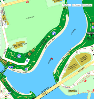
Kallang Riverside Park or KLP is a riverside park located on the opposite bank of Marina Promenade that’s really popular with the water sport crowd. It extends across the river, covering both sides of it with a supposed beach, exercise corners and other sports facilities. Just a little down from the park is the Sports Hub with the National Stadium and the OCBC Aquatic Centre. There’s plenty of facilities here so I will just touch on the major ones.


KLP: Beach

If you look at the map above, you can see that there are supposed to be three beaches located in the area. But well, these beaches aren’t really the type beaches one typically pictures in their mind.
Well, it is not really a beach per say but more of a launching platform for boats as can be seen in the picture on the left
. So Kallang Riverside won’t really be our first choice for getting out for a beach day. But the good news is that the area is being earmarked to be developed into a sort of pseudo resort in the years to come.


Just look at the URA master plan. I don’t think anyone there today can truly imagine the place being developed into a waterside resort.
On the sustainability front this will really be a big game changer. Just imagine, we are literally going to change the natural ecosystem from an inland river to that of a manmade beach. It boggles the mind! It’s the very antithesis of sustainability which is about the endurance of systems. This raises several pertinent questions. First off, is a man-made beach like this sustainable? The creation of the beach would mean shaking up the biodiversity of the existing park to include more species native to beaches. At the same time, what are the potential effects of a beach on other communities further down the river? Typically a beach is exposed to the wider ocean but in this case, the beach is sited beside mouth of the river. So how does this affect the Marina Reservoir area that’s further downstream?

Kallang Riverside: Sports Hub

The Singapore Sports Hub is the newest development in the area now. It’s facilities occupy an entire bank of the Kallang Basin and has a dock along its side. The Sports Hub caters to a wide variety of water sports through this dock. I saw dragon boats, kayaks, canoes and sailing boats at its docks. There’s even those peddle boats you usually see in cheesy romance movies.

I think the Sports Hub is the surest indicator of the direction in which development in the area is going. The focus is surely to transform the Kallang River/Basin area into a recreational river park that caters to a wide variety of water-related activities. Most of the activities in the area now are low in pollution so we do not really see an impact on the river quality. But as the amount of activities in the area increases, then naturally the pressure on the ecosystem changes. Throw in a manmade beach and the dynamics change even further. 

References:
https://www.ura.gov.sg/uol/master-plan/View-Master-Plan/master-plan-2008/Growth-Area/Kallang-Riverside/Life-a-beach.aspx


Sunday, 16 October 2016

Kallang River: Marina Promenade

Kallang River: Marina Promenade

So the first part of Kallang River I visited was Marina Promenade. It is located right after the Merdaka Bridge along Nicoll Highway and leads all the way up to the Singapore Flyer and the Helix Bridge.
Marina Promenade is home to several features of the area such as the biodiversity garden and the office of the Waterways Watch Society. It’s quite popular on Sundays as a picnic spot for various groups as well.


Marina Promenade also overlooks Kallang Riverside Park on the other side of the river. Kallang Riverside Park is one of the key locations of the area and thus we will go into further detail when I get around to visiting it.


Biodiversity Pond

One of the more interesting features of Marina Promenade is the Biodiversity Pond & Park. It is a little area built near the pier of the nearby that consists of various educational exhibits about biodiversity and sustainability. Most of the exhibits in the area are made of recycled material. The signboards are made of wooden pallets, structures are made of granite slabs and seats area made of old repainted pieces of lumber.


There are little games around such as this “interactive granite slab” where players play tic tac toe on the slab by wetting their finger using the tap nearby and drawing on the slab. It’s quite the means of reusing a slab of concrete if you ask me.

 Further on we see a brief history of this corner which was quite enlightening. This corner came about as a result of flotsam having the tendency to gather in the dead spot of the pier. So the Waterways Watch Society decided to build a barrier to prevent flotsam from collecting and it slowly evolved to become the biodiversity garden today. This is really interesting because it highlights how governance of such an ecosystem need not be top down but can be bottom up where volunteers make improvements to the ecosystem to enhance its sustainability.


Here’s a picture of the park pond which used to be the dead spot of the pier. It is now however an actual pond that is somewhat separated from the river through a floating barrier. Which interestingly has allowed water surface plants to grow there!

Waterways Watch Society

The office of the Waterways Watch Society is also located a few metres away from the biodiversity park right under the Merdeka Bridge.
The group seems to be really active as the facilities seem well tended and there are additional exhibits located outside their premises.


For example there is this garden beside their office that seems to be a mix of plants and fruits. It is definitely tended to going by the amount of wooden structures in it. Amusingly enough there’s also a sign at the corner of the garden that says “VIP Entrance for Otters” implying that otters visit this garden on occasion.


 Duck Tours Embarkation Point

Last of all, there’s also a spot further down the river that’s the embarkation point for Duck Tours. Duck Tours is a sort of a mix land and river tour rolled into one where tourists can sit on their amphibious vehicles to visit various places around the Marina Bay area. This is one area which diverges drastically from Bedok Reservoir Park as tourism is an additional draw to the area.
Marina Promenade is home to several features of the area such as the biodiversity garden and the office of the Waterways Watch Society. It’s quite popular on Sundays as a picnic spot for various groups as well.


Kallang River: Ecosystem Services

Kallang River: Overview

Looking back, it was a good thing that we had a short break last week from conducting more visits as it allowed me to collect my thoughts. I usually looked at these complex ecosystems from a stakeholder perspective; that I focused on the needs of the stakeholders and how these needs are balanced through the governing process.
It was possible before because of the limited amount of stakeholders involved in the previous complex socio-ecological systems. In the case of Kallang River though, there is a need to approach the analysis from a services perspective because of the sheer scale of Kallang River and its stakeholders involved.

Ecosystem Services

The Millennium Assessment(MA) published in 2005 identified four main categories of services that an ecosystem provides. The four services are supporting, regulating, provisioning and cultural. We went into depth in an earlier post but in essence, the four are ways that humankind benefits from ecosystems.
The more obvious service that Kallang River provides is Provisioning. The river is part of the Marina Catchment Area and thus forms an integral part of Singapore’s water supply. Fishing is allowed along the river but it is usually recreational instead of fishing as a source of food. Therefore the river’s food provisioning service isn’t a main draw.
Cultural services are perhaps the main provision of the river in modern times. It plays host to a variety of human activities ranging from recreation to education. There are numerous recreational facilities located along the river from the Water Sports Centre at the Singapore Sports Hub to the park connector tracks that run along most of the river.
The river also help improve the quality of life for residences near the river as parks are often built along the river. Families living near the river have easier access to nature as a result of these parks. The view of the river is also aesthetically pleasing and many developers seek to leverage upon this by marketing new residences that include a river view.
Celebrations and events are also often held along the river. The annual National Day fireworks are usually set off from boats on the river and boat races usually take place near the mouth of the river.
Regulatory and Supporting services are much less obvious as they are usually not immediately perceivable by us. The Millennium Assessment writes that regulatory services that rivers provide are the maintenance of water quality via natural filtration and serve as flood control.  Supporting services that rivers provide is the creation of an ecosystem that allows for predator/prey relationships.

Governance of Services

Now that we have identified these key services the river provides, the next step would be to look into how the river is governed to ensure these services remain sustainable. The main authorities managing the river are the same as those behind Bedok Reservoir Park namely, the National Environment Agency, National Parks for the facilities along the river and the Public Utilities Board for the water-related facilities.
However, there is an increased amount of non-government actors involved in the governance of the park compared to Bedok Reservoir Park. For example, the Waterways Watch Society an independent volunteer group seems to be far more active when it comes to the river as they have an office in the area.
Thus at first glance, governance in this case could be more decentralised than previous examples.


Waterways Watch Society. Retrieved from Waterways Watch Society: http://www.wws.org.sg/

Kallang River: A History

Kallang River: History

Kallang River (Source: Otterman.wordpress.com)
The Kallang River is the longest river in Singapore at 10km long flowing from the Lower Peirce Reservoir to Nicoll Highway. The river’s place in Singapore’s history is well varied as a source of fresh water for early settlers in Singapore; means of transportation for traders and recreation.
Today, the river is largely reserved for recreation and as a source of water. Numerous recreational facilities can be found along the river with many concentrated at its mouth near Kallang Basin.


1977- 1987: Cleaning Up

Kallang River Bank (Source: PICAS)
Unlike its modern day iteration, the Kallang River was said to have been filled with debris and waste in the early 1970s.
The river banks were overcrowded with squatters and industry then with the vast majority releasing various forms of discharge into the river. Amongst the industries were pig farms, duck farms and hawkers all releasing a mix of waste into the river. As you can imagine, the river was hardly fit for human activities then due to its severe pollution.


It wasn’t until 1977 that the then Prime Minister Lee Kuan Yew launched a clarion call for the clean-up of Singapore’s rivers (Choo, 2014). As a result, the Ministry of Environment placed a target; that the river be fit for fishing within 10 years.

There were a few issues that had to be tackled before the clean-up could actually really shift in to high gear. First, the human population around the river bank was significant. Housing had to be found for these persons before they could be moved away from the river before clean up could commence. Second, the river was still a transportation route then with hundreds of boats such as bumboats plying the river. The cleaning up of the river meant that all of this commerce had to be shifted elsewhere.

Kallang River Clean Up (Source: The Straits Times)
The clean-up team led by then Environment Ministry Permanent Secretary Lee Ek Tieng resolved the two problems by shifting all of the riverside population to public housing further inland and building a new anchorage point at Pasir Panjang to deal with all the commerce that would have come to the river. The industries were either relocated to industrial estates or totally phased out in the case of farms.As such, the crew could focus their efforts on the clean up on the river which eventually took 10 years and cost S$170 million.

1987: Clean Rivers Education Programme

But just cleaning up the river isn’t enough. Improper dumping of waste can still cause the river to revert back to its pre-clean up days. To prevent the river from regressing, the Singapore government launched the Clean Rivers Education Programme in 1987 to raise awareness of the negative effects of releasing waste into Singapore’s waterways and to encourage people to keep the waterways pollution-free (National Libary Board, 2004).

The programme released videos on keeping the rivers clean to the public with large emphasis on students to call upon them to participate in keeping the rivers clean.

Beyond 1987: Reshaping the River

The Kallang River has changed significantly since then with the return of aquatic life and increase in recreational activities in the River. The river has also become an attraction with river cruise boats offering tourists a chance to travel along its length. It’s also become an integral part of the Marina Reservoir water catchment area with the addition of the Marina Barrage Dam in 2008.

Bibliography

Choo, F. (5 Jul, 2014). 5 Interesting Facts about the Singapore River Clean Up. Retrieved from The Straits Times: http://www.straitstimes.com/singapore/5-interesting-facts-about-the-singapore-river-clean-up
National Libary Board. (2004). Clean Rivers Education Programme and Clean River Commemoration. Retrieved from Singapore Infopedia: http://eresources.nlb.gov.sg/infopedia/articles/SIP_398__2008-12-02.html